(PSSST! - We have actually returned home safe and sound, but since I wasn't able to make blog postings contemporaneously, let's pretend that the trip is still underway, but going very sss-lll-ooo-www-lll-yyy. There's more scenery and more stories to share.)
Back On the Road The time had finally come to start up the storied ALASKA-CANADA or ALCAN Highway. Our most northerly destination would be Fairbanks, AK. However, we would be spending the lion's share of our time traversing the Canadian Provinces of northern Alberta, a corner of British Columbia, and the vast Yukon along the way, before re-entering US territory at the Alaskan border.
The starting point monument in Dawson Creek, British Columbia
Time zones encountered along the Alaska-Canada Highway
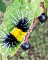
and the moth that evolves from the caterpillar. Amazing transformation.
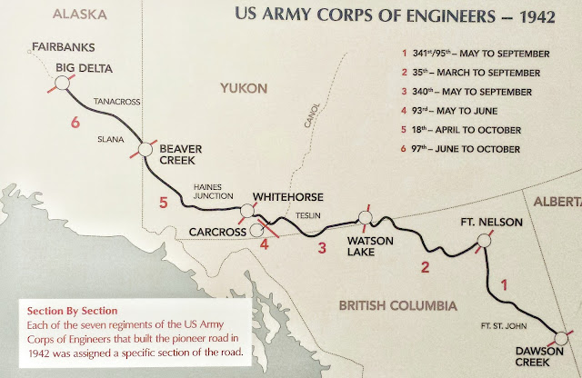
Map of the ALCAN Highway with the timeline of construction.
Just after the Pearl Harbor attack and entry of the US in to the Pacific theater of war, President Roosevelt and Congress, as well as Canada, became concerned about a potential Japanese invasion via Alaska. Shortly thereafter, 2 tiny islands in the distant western Aleutian Chain were occupied by the Japanese Army. (The Japanese abandoned one of those and were forced off the other by the US Army.) Therefore, in order to convey troops and defenses to the Alaskan territory, the construction of a highway to Fairbanks, from Dawson Creek was authorized. Overall, the project involved 11,000 American soldiers, working under grueling conditions in non-stop, daily 12 hour shifts, over slightly more than 8 months (!) through the spring to fall of 1942, for an estimated cost of almost $20 million for the basic passage. A number of soldiers died due to injuries, accidents, and the cold. Many were African American from the Deep South. By the time the road was fully completed, cost was $135 million or $66,160 per mile, in 1944 dollars.
We walked the Kiskatinaw Bridge, located on the old Alaska highway. It is a curved, wooden, 531 foot long structure that is the only original timber bridge built along the Alaskan highway that is still in use today. Still pretty sturdy.
 Left, the memorial marker at Charlie Lake. This was the site of the sinking of a heavily loaded U.S. military pontoon boat (1942) while attempting to cross the lake, in a sudden storm. Sadly, 7 U.S. soldiers drowned, while 5 were heroically rescued by a local man in a small rowboat.
Vintage US Army earth-moving machinery, used during the building of the original ALCAN Highway (minus the blue bucket). Most soldiers learned to use this equipment "OJT" while battling problems ranging from choking swarms of mosquitos and sucking mud to frostbite and permafrost.
Next - Far Northeastern British Columbia


No comments:
Post a Comment