Thursday, September 22, 2016

You can, I can, WE ALCAN - Starting the Highway

You can, I can, WE ALCAN - Starting the Highway

(PSSST! - We have actually returned home safe and sound, but since I wasn't able to make   blog postings contemporaneously, let's pretend that the trip is still underway, but going very sss-lll-ooo-www-lll-yyy. There's more scenery and more stories to share.)

Back On the Road The time had finally come to start up the storied ALASKA-CANADA or ALCAN Highway. Our most northerly destination would be Fairbanks, AK. However, we would be spending the lion's share of our time traversing the Canadian Provinces of northern Alberta, a corner of British Columbia, and the vast Yukon along the way, before re-entering US territory at the Alaskan border. 


The starting point monument in Dawson Creek, British Columbia

Though we had already been on the road for over 2 weeks, we hadn't "officially" started the ALCAN until we reached the town of Dawson Creek, Pop.-12,000. This small community, not to be confused with Dawson City in the Klondike, marks the "Mile 0" of the highway built to link Canada and the lower 48 with Alaska, specifically Fairbanks, over 1500 miles distant.


Time zones encountered along the Alaska-Canada Highway


"Yellow Woolly Bear" or Spotted Tussock Moth Caterpillar (sans spots in Alberta),
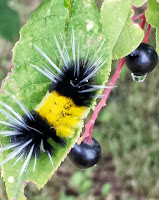
and the moth that evolves from the caterpillar. Amazing transformation.


Map of the ALCAN Highway with the timeline of construction.

Just after the Pearl Harbor attack and entry of the US in to the Pacific theater of war, President Roosevelt and Congress, as well as Canada, became concerned about a potential Japanese invasion via Alaska. Shortly thereafter, 2 tiny islands in the distant western Aleutian Chain were occupied by the Japanese Army. (The Japanese abandoned one of those and were forced off the other by the US Army.) Therefore, in order to convey troops and defenses to the Alaskan territory, the construction of a highway to Fairbanks, from Dawson Creek was authorized. Overall, the project involved 11,000 American soldiers, working under grueling conditions in non-stop, daily 12 hour shifts, over slightly more than 8 months (!) through the spring to fall of 1942, for an estimated cost of almost $20 million for the basic passage. A number of soldiers died due to injuries, accidents, and the cold. Many were African American from the Deep South. By the time the road was fully completed, cost was $135 million or $66,160 per mile, in 1944 dollars.


We walked the Kiskatinaw Bridge, located on the old Alaska highway. It is a curved, wooden, 531 foot long structure that is the only original timber bridge built along the Alaskan highway that is still in use today. Still pretty sturdy.


Left, the memorial marker at Charlie Lake. This was the site of the sinking of a heavily loaded U.S. military pontoon boat (1942) while attempting to cross the lake, in a sudden storm. Sadly, 7 U.S. soldiers drowned, while 5 were heroically rescued by a local man in a small rowboat. 


 Vintage US Army earth-moving machinery, used during the building of the original ALCAN Highway (minus the blue bucket). Most soldiers learned to use this equipment "OJT" while battling problems ranging from choking swarms of mosquitos and sucking mud to frostbite and permafrost.


Next - Far Northeastern British Columbia


Saturday, September 10, 2016

Jasper's Weird Medicine and Maligned Maligne

Jasper's Weird Medicine and Maligned Maligne


Jasper National Park in Alberta is another gem of the Canadian Rockies. The town by the same name is the crossroads for those planning to explore the park and those heading north to the ALCAN Highway, like yours truly. 

But Jasper has many beautiful and special places that compel one to linger a bit longer exploring its "secrets".

 One such enigma was Medicine Lake. It was thought to be an area of "powerful medicine" by early Native residents because the lake drained away each fall and   winter, only to refill during the spring and summer. As it turns out, the floor of the lake bed is so porous, that it cannot fill unless it is being replenished with snow-melt and rain at a faster rate than the water seeps out.


Just down the road is Maligne Lake, pronounced "Mah-LEEN", but with the meaning of a bad or evil place. First explored by a Mary Shaeffer, this body of water is truly breathtaking when viewing it's mirrored surface and necklace of snowy peaks.  So serene!
Those wishing to glide across the waters and explore the shoreline can bring or rent a canoe or kayak.

 We rode the excursion boat (in the background) to see more of the lake and surrounding cliffs and glaciers

 Aquamarine colored waters from silty glacier-melt and sky reflections

 Gentle ripples in side coves along the shore.

 A place called "Spirit Island" - of great, sacred significance to the indigenous peoples living in the area.

 Making waves on the excursion boat on our way back to the head of the lake.

"Lake Annette", a local's favorite with a bit of beach to encourage a bit of creativity in sand art.

Another local (female elk) enjoying some browsing along the edge of Lake Annette despite numerous folks picnicking and hiking in the vicinity.

Next, we continue our northward roaming toward northern BC and the Yukon.
Barbara and Paul

Saturday, September 3, 2016

Pretzeled Railroads and Fields of Ice

Pretzeled Railroads and Fields of Ice

Just north of the Lake Louise area, we took a brief westward jaunt into British Columbia's 
Yoho National Park to see the Spiral (railroad) Tunnels. 


Back in the 1880's, in their haste to complete the Canadian Pacific Railway line, the managers authorized the construction of a temporary, but very steep, segment over Kickinghorse Pass and down the "Big Hill". It had a grade of 4.4% or 116 feet per mile. After many incidents, derailments and deaths, this section was replaced with construction of the Spiral Tunnels. Apparently borrowed from the Swiss, the concept was to dig a pair of three-quarter turn circle tunnels into mountainsides across the valley from each other. The grade reduced to 2.2%. 
As a consequence, from different vantage points near the tunnels, it is possible to see the front locomotive leaving the upper end of the tunnel heading north, while the caboose enters the lower end of the same tunnel heading south. Look closely in the lower left corner of the photo below to see the single train on two different levels proceeding in opposite directions.


This tourist lifestyle is TOUGH on a body!
(Snoozing biker at a rest stop)

Back in Alberta, another indescribably blue lake, Peyto Lake, north of Lake Louise, entering the Icefields Parkway.

The Icefields Parkway conducts drivers between the Banff Park northward to Jasper town, paralleling the Continental Divide for 230km. The main attraction is the gargantuan, but shrinking Columbia Icefield, with its multitude of glaciers fanning out around it. 

The visitor driving the Parkway sees waterfalls, glaciers, lakes and rivers, brimming with glacier-melt milky waters.

Sunwapta Falls on the Sunwapta River (meaning "turbulent") is within Jasper National Park. It has a drop of 60 ft. and is a roaring 30 ft. wide.


Athabasca Falls, from the river of the same name is even more voluminous and drops 80 feet, tumbling over hard quartzite stone above through softer limestone below, to carve a narrow gorge.


Next, we're bound for the scenic and very popular Jasper National Park, 4200 sq. miles of mostly wilderness; chock full of gorgeous lakes, glaciers, mountains and wildlife.